
- Some web pages at this site contain forms that permit retrieval of archived data.
Fields such as ENDING DATE, ENDING TIME and TIME
STEP are used. If these fields are left blank, the data retrieval program will
use the default values for current date, current time, and 24-hours respectively.
- If an ENDING DATE is specified and the ENDING TIME field is left blank, the program will default to midnight (i.e. 2400) of that day but the
graphics display will show a time of 00 hours for the next calendar day.
- Some pre-processed data tables at this site use Greenwich Mean Time (GMT), a.k.a. Coordinated Universal Time (UTC). GMT differs from local Denver
time by 6-hours during MDT and 7-hours during MST. The LDAD tables displayed from the Weather Information web page use GMT.
- Most graphical data displays are GIF images. After the image appears, always
check the ending date and time to make sure the data reflects the time period you
requested. If not, press your REFRESH or RELOAD button. The correct image should
then appear. If this does not work try holding down the [Shift] Key while
left-clicking the REFRESH button.
- Some images contain links to other maps, data tables, web pages, etc. The '#' and '$' symbols are used as icons
for subsequent graphical/text products. Descriptive pop-up text boxes are provided to
aid navigation. Some browsers may not be able to display text boxes but a mouse pointer
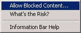
will indicate when an image has subsequent links. You can test your system's pop-up capabilities by clicking on the UDFCD Homepage link in the lower left. With Windows XP and Internet Explorer you may get the following message at the top of your browser. Simply click on the message and then select Allow Blocked Content... as show.

- When displaying rain maps for past events, you may note some bogus values
exceeding 76-inches. This is due to recent upgrades to ALERT data transmitters at
certain gaging stations in Boulder County and in the Lena Gulch basin in Jefferson County.
To estimate the actual measured rainfall, subtract 76.69" from the amount displayed.
- Use your browser BACK BUTTON to return to previous web pages. Real-time map
displays are generally launched in the main frame window, but in some cases a new browser
window is launched. This is done to aid with browser printing.
- Graphical data displays are automatically refreshed every 5-minutes. This
feature does not work when viewing tables and other text products.
- Please read our Disclaimer page and email us if you have problems using this site.
 |
