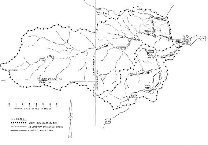
II. THE BEAR CREEK DRAINAGE BASIN
Drainage Basin Description
Bear Creek, which rises in the mountains southwest of Denver, is a left bank tributary
of the South Platte River. The total drainage area at the mouth is 261 square miles of
which 164 square miles are upstream of Morrison. The basin, shown in Figure II-1, includes
parts of Jefferson, Clear Creek and Park Counties, and ranges in elevation from 5,780 feet
at Morrison to 14, 264 feet at Mt. Evans. Idledale, Kittredge and Evergreen are towns
located in Jefferson County along Bear Creek upstream of Morrison. Major tributaries
entering Bear Creek below Evergreen Lake include: Cub Creek, Troublesome Creek, Swede
Gulch, Cold Spring Gulch, Sawmill Gulch at Idledale and Mount Vernon Creek at Morrison.
Bear Creek flows into Bear Creek Lake just east (downstream) of the Dakota Hogback
geologic formation at Morrison. This facility is a major flood control reservoir
constructed and operated by the U. S. Army Corps of Engineers. East of the Hogback, Rooney
Gulch enters Bear Creek Lake from the north and Turkey Creek enters the lake from the
south. The City of Lakewood Parks Department is responsible for public safety in the park
area surrounding Bear Creek Lake. Evergreen Dam is a 380’ long, 34’ high
structure located on the main stem of Bear Creek above Cub Creek at Evergreen, forming a
40-acre lake known as Evergreen Lake. This reservoir is not a flood control facility but
it does impound 670 acre-feet of water.
Flood History
Information on historical flooding in the Bear Creek basin has been obtained from the
following sources:
1. Flood Plain Information, Metropolitan Region, Denver, Colorado, Volume III
Summary Report Bear and Clear Creeks, South Platte River Basin, and Volume III
Technical Appendix, Bear and Clear Creeks, South Platte River Basin, U.S. Army Corps
of Engineers (USACE), Omaha, Nebraska, January 1966.
2. Floodplain Information, Bear Creek and Mt. Vernon Creek, Morrison, Colorado,
USACE, October 1971.
3. Special Flood Hazard Information Report, Bear Creek, Denver Metropolitan Area,
USACE, December 1972.
Figure II-1
Bear Creek Drainage Basin
Additional historic flood information was obtained from the Jefferson County Department
of Emergency Management and the Canyon Courier newspaper in Evergreen, Colorado.
Since the 1860’s there have been 24 known instances of floods in the Bear Creek
basin that collectively have caused 45 deaths and considerable property damage. These
floods occurred in 1866, two in 1878, 1885, 1886, 1893, 1894, 1896, 1903, 1907, 1908, two
in 1921, 1923, 1925, 1933, 1934, 1938, 1946, two in 1957, 1965, 1969 and 1973. Most of the
floods were caused by runoff from intense rainstorms during the summer months. However,
early season floods have resulting from rainfall runoff coinciding with snowmelt flows.
The Bear Creek at Morrison stream gage, located upstream of Mount Vernon Creek, measured
its record flow of 8,600 cfs (estimated) on July 24, 1896. The peak discharge for Bear
Creek during the 1938 flood was estimated to be 9,230 cfs at Morrison with most of the
runoff coming from Mount Vernon Creek . There are no gage records for Mount
Vernon Creek. The total drainage area at the Bear Creek at Morrison gage is 164 square
miles. Mount Vernon Creek enters Bear Creek downstream of this gage and has a drainage
area of only 9.4 square miles. The headwaters of Mount Vernon Creek are at Genesee where
I-70 begins its climb into the mountains along Mount Vernon Canyon. The south side of
Lookout Mountain also drains into Mount Vernon Creek. At the Dakota Hogback the creek
turns south, passing through Red Rocks Park and continuing to its mouth at Morrison, where
a very narrow, confined stream channel exists.
The stream gage at Sheridan, located at Lowell Blvd., has measured Bear Creek flows
continuously since 1927. The Morrison gage has partial records dating back to 1888 and
continuous records since 1922. Table II-1 lists the largest floods recorded at these
gaging stations since 1927. Comparison of the gage records reveals a large variance in
peak discharges for each flood event. In 1933, 1934 and 1938, the storms were concentrated
in the foothills and mountains of Bear Creek, and the resulting flood peaks attenuated
between Morrison and Sheridan. For the other flood dates shown in Table II-1, the majority
of runoff occurred from watershed areas downstream of Morrison or from Turkey Creek. Thus
the peak flows for these floods were greater at Sheridan than Morrison. Turkey Creek was
the known principle contributor for the 1957, 1965, 1969 and 1973 events. The flood of
1973 was the last significant event in the Bear Creek basin.
TABLE II-1
BEAR CREEK PEAK FLOOD DISCHARGES
IN CFS
| DATE |
MORRISON |
SHERIDAN |
| July 7, 1933 |
8,110 |
3,000 |
| August 9, 1934 |
4,620 |
1,300 |
| September 2, 1938 |
6,200 |
2,810 |
| August 21, 1957 |
1,640 |
2,560 |
| July 25, 1965 |
1,030 |
2,900 |
| May 7, 1969 |
2,340 |
8,150 |
| May 6, 1973 |
1,480 |
3,750 |
The 1971 USACE report characterizes Bear Creek floods as rapid concentrations of
runoff, sharp peak discharges and rapid flood recession. The peaking time for floods on
Bear Creek at Morrison is about 3 to 5 hours after the causing rainfall, while floods on
Mount Vernon Creek can peak between 1 and 3 hours. Several local residents stated that
during the Mount Vernon Creek flood of 2-3 September 1938, it was about 1.5 to 2 hours
from the time the flood reached Morrison until the water had receded enough to permit
travel on Main Street. A large flood on Bear Creek at Morrison due to intense rainfall
could last up to 12 hours and the duration of flooding could be extended even more in the
case of coincident high snowmelt runoff.
Some major past floods on Bear Creek and Mount Vernon Creek are described to illustrate
the dangerous flood potential at Morrison. One of the earliest reports concerns a storm on
21-23 May, 1876, reported by the Denver Tribune on June 5 of that year; "...
informs us that he has never seen such destruction in the region as resulted from the late
storm. He spent some days in the valleys of Soda and Bear Creeks and their tributaries and
found new gullies worn to the depth of 20 feet in the action of the raging torrents."
Another report stated that a widespread storm on 29 May through 1 June 1894, in the
vicinity of Morrison, produced a flood that caused the loss of bridges, railroad tracks,
houses, and destroyed the highway in the canyon. Descriptions of some more notable flood
events follow:
 | July 24, 1896
Intense rainfall on 24 July 1896 centered on Cub Creek, a tributary of Bear Creek near
Evergreen. "Without a moment's warning the largest flood that ever came down Bear
Creek struck Morrison about 8 o'clock tonight (July 24), sweeping everything in its path
... although the water came down through the town nearly 3 feet deep in the main street,
the buildings in the business section all withstood it." Twenty-seven lives were
lost in the flood (available records do not indicate where the deaths occurred) and severe
damages were reported from Evergreen to the mouth of Bear Creek. No rainfall records of
this flood are available. The peak flow on Bear Creek at the Morrison gaging station was
estimated at 8,600 cfs, which is the flood of record for the gage. The most recent
hydrologic studies indicate that this flood would have a one in 40 chance of occurring in
any year. It is not known to what extent Mount Vernon Creek contributed to the Morrison
flooding. |
| July 7-8, 1933
"Five persons known dead ... property damage of unestimated degree and nearly all
the highway between Mt. Morrison and Idledale ruined, is the toll up to date of one of the
most devastating floods last Friday afternoon (July 7) ever to visit the Bear Creek
Watershed. ... A cloudburst at about 1 o'clock in the neighborhood of Idledale sent a wall
of water down Saw Mill Gulch leading to Bear Creek, and another raging torrent down Vernon
Creek. ... The Vernon Creek waters reached a height of 15 feet ... in the narrow passage
between the business houses. … The Highway up beautiful Bear Creek Canyon between Mt.
Morrison and Idledale is practically ruined." The peak discharge at Morrison was
8,000 cfs on Bear Creek and estimated as 1,500 cfs on Mount Vernon Creek. |
| August 9, 1934
The flood of 9 August 1934 in the Bear Creek basin was caused by cloudburst-type rainfall
near Kittredge and at the head of Mount Vernon Creek. Six lives were lost and much
property damage resulted. It was reported that Mount Vernon Creek ran higher than the
previous year and much of the canyon roadway was destroyed. Damage to Morrison was reduced
because the Bear Creek peak flow passed through the town before the Mount Vernon Creek
high water arrived. |
| September 2-3, 1938
A widespread thunderstorm that began over the eastern slope of the Front Range on 30
August became most intense in the Morrison area on 2 September. An unofficial report
stated that 7.9 inches fell just north of Morrison in six hours. The heaviest rainfall
centered on the divide between Bear Creek and Mount Vernon Creek. The peak discharge on
Bear Creek at Morrison above Mount Vernon Creek was 6,200 cfs. From post flood
measurements the Mount Vernon Creek peak discharge was estimated at 9,230 cfs at a point
1/2 mile upstream from Morrison. From statements by local residents it appears that the
peak discharge on Mount Vernon Creek reached Morrison at about 7 p.m., preceding that on
Bear Creek by 1/2 hour. Six persons drowned when trapped in their automobile between
Morrison and Kittredge. Damages in the basin were estimated at $450,000. If Morrison had
not been warned, or if the flood had occurred late at night, the number of deaths would
likely have been considerably higher. The photograph on page II-10 (Figure II-5) shows the
relative level of this flood compared with the 100-year flood level. Note that this flood
appears to have exceeded today’s regulatory flood elevation by as much as four feet. |
| August 24, 1946
On August 24, 1946, a heavy rain near Idledale caused Bear Creek to overflow. A Morrison
woman was swept from her stranded car and drowned. |
| August 21, 1957
On the afternoon of 21 August 1957, thunderstorms occurred over the Bear Creek basin with
heavy rain and hail beginning about 1 p.m. east of Squaw Pass and northwest of Evergreen.
At most locations the rain stopped within an hour. The Mount Vernon Creek peak discharge
at Morrison was estimated at 1,000 cfs at 2:30 p.m., and 1,640 cfs on Bear Creek at about
3 p.m. While most damages from Bear Creek occurred downstream of Morrison, Mount Vernon
Creek left debris on the grounds of six or seven residences in Morrison, flooded a garage
and a used car lot, and broke a water main. State Highway 8 at Morrison was closed upon
warning of the flood. Later, portions of the highway were flooded by both streams. |
| July 25, 1965
On 23-24 July 1965, heavy rains over the headwaters of Bear Creek caused minor flooding
throughout its length. Most damages occurred downstream of Morrison. A peak discharge of
1,030 cfs was measured for Bear Creek at Morrison on July 25, 1965. |
| May 7, 1969
Heavy rains from 4-8 May 1969 resulted in flooding in the Bear Creek basin with most
damages occurring downstream from Morrison. A weather station at Morrison reported a total
storm rainfall of 11.27 inches, with a maximum daily amount of 5.77 inches. Unofficial
rainfall amounts in the basin varied from 6.7 inches to 11.8 inches during the 5-day storm
period. The peak flow for Bear Creek at Morrison was 2,340 cfs on May 7, 1969. The
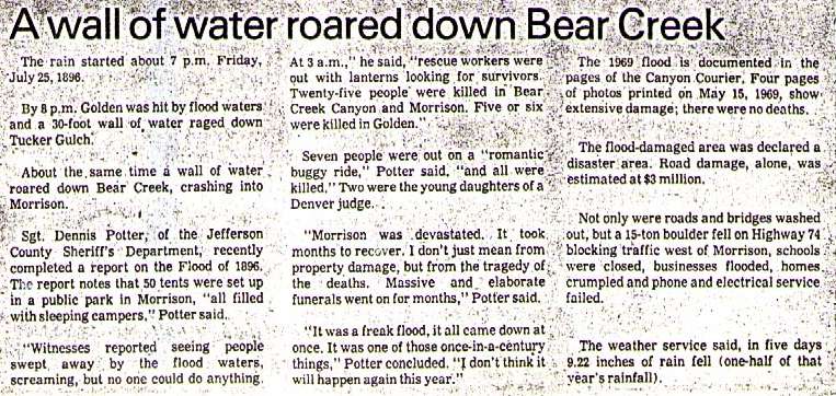
following 1969 newspaper clipping also provides interesting accounts of the 1896 floods on
Bear Creek at Morrison and Tucker Gulch at Golden. |
Snowmelt Flood vs. Rainfall Flood Potential
To evaluate the snowmelt vs. rainfall flood potential at Morrison, Idledale, Kittredge
and Evergreen, a discharge-frequency relationship at each location was established for
both types of events. The Flood Insurance Study for Jefferson County, Colorado, originally
prepared by PRC Engineering Consultants, Inc., provided the most complete hydrology study
for Bear Creek. Included in that report was an estimate of discharge-frequency
relationships for both snowmelt and rainfall floods at the Morrison stream gage. The study
procedures were extended to develop the desired data and the results are summarized in
Table II-2.
TABLE II-2
SUMMARY OF RAIN AND SNOWMELT FLOOD POTENTIAL
| Location |
Drainage
Area
(mi2) |
Return Period
& Discharge (cfs)
Rainfall Events |
Return Period
& Discharge (cfs)
Snowmelt Events |
10-yr |
50-yr |
100-yr |
500-yr |
10-yr |
50-yr |
100-yr |
500-yr |
| Morrison |
164 |
2,180 |
8,130 |
13,490 |
39,850 |
600 |
1,080 |
1,310 |
1,940 |
| Idledale |
158 |
2,130 |
7,940 |
13,180 |
38,930 |
590 |
1,060 |
1,290 |
1,910 |
| Kittredge |
139 |
1,970 |
7,330 |
12,170 |
35,930 |
560 |
1,000 |
1,220 |
1,800 |
| Evergreen |
105 |
1,650 |
6,150 |
10,200 |
30,130 |
490 |
890 |
1,070 |
1,590 |
Anticipated Warning Times
Tables II-3 summarizes the estimated warning times that the automated stream gages
provide to downstream areas. Lead times are given for three flood wave velocities of 12,
15 and 18 feet per second (fps). The value of 15 fps is assumed to be a reasonable
estimate, but times based on 12 and 18 fps velocities are included to illustrate how flood
travel times can vary. The lead times shown do not factor in the times required for data
analysis and decision-making.
TABLE II-3
AUTOMATIC STREAM GAGES
LEAD TIME IN MINUTES FOR
INDICATED FLOOD VELOCITIES IN FPS
| ALERT Gage & I.D. Numbers |
MORRISON |
IDLEDALE |
KITTREDGE |
EVERGREEN |
FPS � |
12 |
15 |
18 |
12 |
15 |
18 |
12 |
15 |
18 |
12 |
15 |
18 |
| Rosedale #2253 |
106 |
85 |
71 |
83 |
66 |
55 |
51 |
41 |
34 |
33 |
26 |
22 |
| Cub Creek at Blue #2273 |
98 |
78 |
65 |
74 |
60 |
50 |
42 |
34 |
28 |
24 |
19 |
16 |
| Evergreen Lake #2223 |
74 |
59 |
49 |
51 |
40 |
34 |
18 |
15 |
12 |
-- |
-- |
-- |
| Bear Creek below Cub #2233 |
73 |
59 |
49 |
50 |
40 |
33 |
17 |
14 |
12 |
-- |
-- |
-- |
| Cold Spring Gulch #2243 |
38 |
30 |
25 |
14 |
12 |
10 |
-- |
-- |
-- |
-- |
-- |
-- |
| Red Rocks Park #2373 |
12 |
9 |
8 |
-- |
-- |
-- |
-- |
-- |
-- |
-- |
-- |
-- |
Flood Elevations in Morrison
The following photographs (Figures II-2 through II-5) were taken from the Morrison
Flood Insurance Study. Each photo depicts the 100-year flood level at various locations in
Morrison. Figure II-5 also shows the approximate high water mark for the 2-3 September
1938 flood.
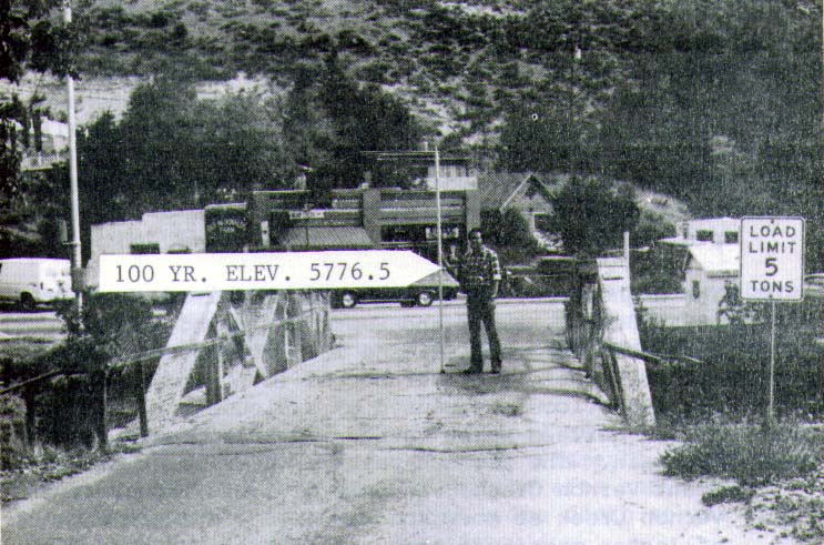 |
Figure II-2 Park Avenue bridge
over Bear Creek in Morrison |
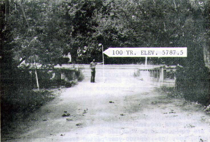 |
Figure II-3 Canon Street
bridge over Bear Creek in Morrison |
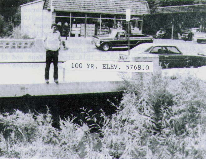 |
Figure II-4 Colorado Highway
74 bridge over Mount Vernon Creek in Morrison at confluence with Bear Creek |
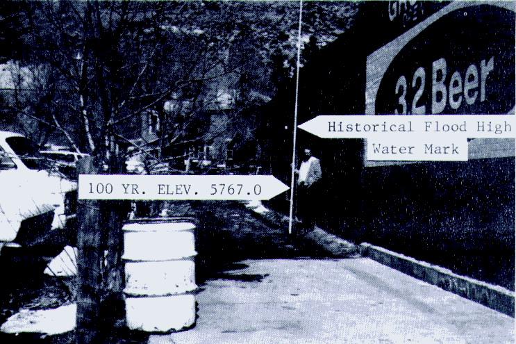 |
Figure II-5 Bear Creek flood
levels on side wall of store in Morrison between Market Street and Mount Vernon Street,
downstream of Mount Vernon Creek. Historic high water mark depicts level of 1938 flood. |
References
the following documents contain additional hydrologic data, flood photos, historic
flood descriptions, floodplain delineations and other pertinent information, and should be
considered supplemental to this flood warning plan:
1. UDFCD, Flash Flood Warning Planning, Bear Creek, prepared by UDFCD, GRD
Weather Center and Leonard Rice Consulting Water Engineers, January 1981.
2. UDFCD, Flood Hazard Area Delineation, Southern Jefferson County, prepared by
PRC Engineering Consultants, Inc., December 1981.
3. UDFCD, Flood Hazard Area Delineation, Bear Creek, prepared by Gingery
Associates, Inc., December 1979.
4. FEMA, Flood Insurance Study, Unincorporated Jefferson County, prepared by
Gingery Associates (August 1983), revised July 4, 1989.
5. FEMA, Flood Insurance Study, Town of Morrison, prepared by PRC Engineering
Consultants, Inc., June 1, 1982.
|